


DETROIT/PONTIAC, Mich. — The National Weather Service has issued a hazardous weather outlook for portions of southeast Michigan, including Midland, Bay, Huron, Saginaw, Tuscola, Sanilac, Shiawassee, Genesee, Lapeer, St. Clair, Livingston, Oakland, Macomb, Washtenaw, Wayne, Lenawee, and Monroe counties.
Today and Tonight
No hazardous weather conditions are expected during this time.
Thursday through Tuesday
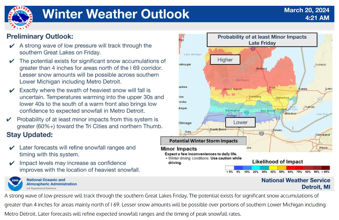
On Friday, accumulating snowfall is anticipated over most of southeast Michigan. There is a potential for significant accumulation, with around 4 inches or more expected north of I-69, and generally 1-3 inches south of I-69. Along the Ohio border, little to no snow accumulation is anticipated. Friday’s weather is expected to create hazardous travel conditions, with roads likely to be snow-covered and slick.
Click here to get real news updates from Dave Bondy sent to your inbox for FREE.
Spotter Information Statement
There is no need for spotter activation today and tonight.
In addition to the hazardous weather outlook for southeast Michigan, a separate outlook has been issued for portions of Lake Erie, Lake Huron, and Lake St Clair.
A gale warning is in effect for the northern half of Lake Huron, with small craft advisories issued for all nearshore waters. Please refer to the latest marine forecasts for specific details.

Small craft advisories will continue on Thursday for southern Lake Huron. Refer to the latest marine forecasts for detailed information.
Spotter Information Statement
Spotter activation is not required today and tonight.
For the latest National Weather Service forecasts, residents can visit www.weather.gov/detroit.
This outlook serves as a reminder for residents to stay informed about weather conditions and to exercise caution during hazardous weather events.
Author’s Note: For further updates and detailed forecasts, please refer to the National Weather Service’s website or local news channels.