


DETROIT, Mich – DTE Energy and Consumers Energy report there are already more than 114,000 power outages in the State of Michigan. The companies say the outages are due to the winter storm blasting the state.
Consumers Energy reports 38,000 customers are without power as of 9 p.m. Friday
DTE Energy reports 76,000 customers are without power as of 9 p.m. Friday
Click here to take a look at the Consumers Energy Outage map
Click here to take a look at the DTE Energy Outage Map
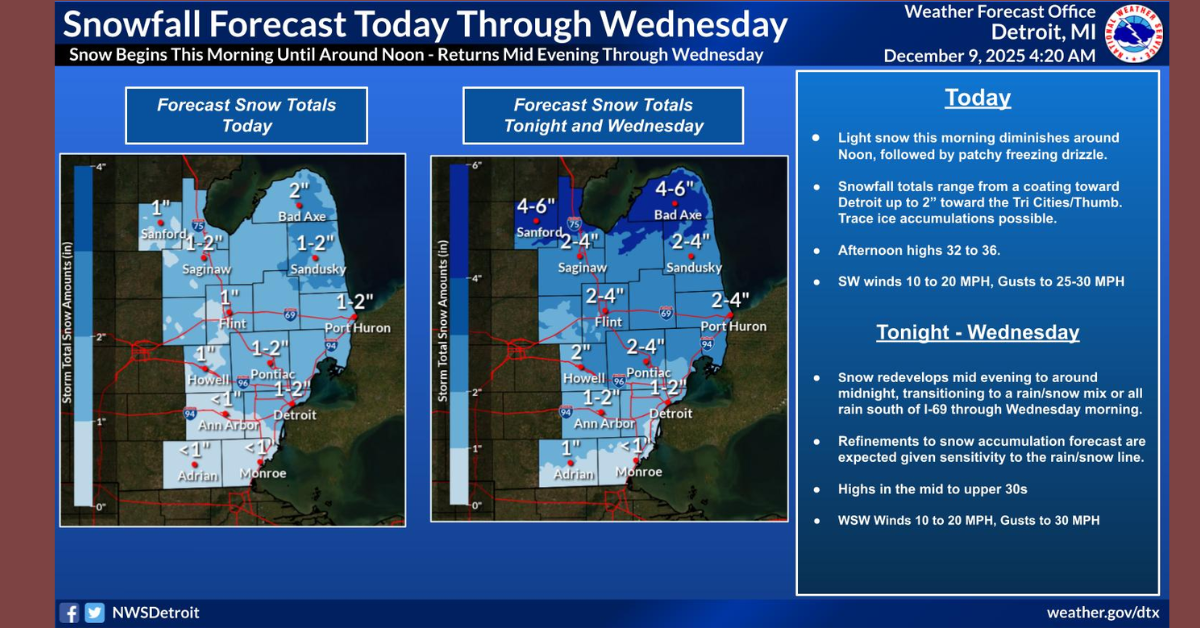
WHAT...Heavy snow. Additional snow accumulations of 6 to 11
  inches. Winds gusting as high as 45 mph.

* WHERE...Midland, Bay and Saginaw Counties.

* WHEN...Until 7 PM EST Saturday.
BLIZZARD WARNING REMAINS IN EFFECT UNTIL 7 PM EST SATURDAY...

* WHAT...Blizzard conditions expected. Total snow accumulations of
  10 to 16 inches with locally higher amounts possible. Frequent
  wind gusts of 35 to 50 mph this evening and tonight with
  potential for 60 mph wind gusts, especially near the Lake Huron
  shoreline.

* WHERE...Portions of Eastern Upper and Northern Lower Michigan.

* WHEN...Until 7 PM EST Saturday.

* IMPACTS...Worst conditions expected this evening and tonight.
  Travel could be very difficult to impossible during this time.
  Widespread blowing snow is expected to lead to significantly
  reduced visibilities for several hours. Significant drifting
  may lead to some impassible secondary roadways. Strong winds
  could cause tree damage and result in power outages. Dangerous
  driving conditions are anticipated this evening and overnight,
  making travel strongly discouraged.
BLIZZARD WARNING REMAINS IN EFFECT UNTIL 7 PM EST SATURDAY...

* WHAT...Blizzard conditions expected. Total snow accumulations of
  10 to 15 inches with locally higher amounts possible. Frequent
  wind gusts of 35 to 50 mph expected this evening and tonight.

* WHERE...Otsego, Montmorency, Crawford, Oscoda and Ogemaw
  Counties.

* WHEN...Until 7 PM EST Saturday.

* IMPACTS...Worst conditions expected this evening and tonight.
  Travel could be very difficult to impossible during this time.
  Widespread blowing snow is expected to lead to significantly
  reduced visibilities for several hours. Significant drifting
  may lead to some impassible secondary roadways. Strong winds
  could cause tree damage and result in power outages. Dangerous
  driving conditions are anticipated this evening and overnight,
  making travel strongly discouraged.