


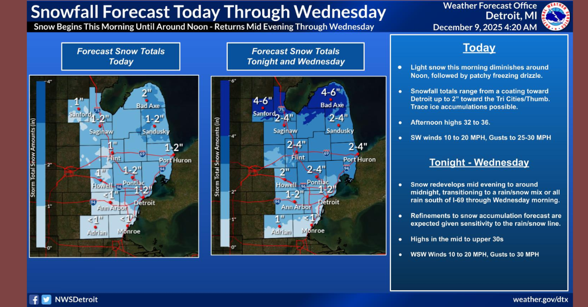


DETROIT, Mich -Southeast Michigan is on alert for severe weather starting today. This morning, there’s a Marginal Risk of severe thunderstorms with potential 1-inch hail. Storms moving southwest to northeast at 45 mph are expected to head into Ontario by noon.
Tonight, the risk extends across Southeast Michigan, with a higher Slight Risk south of M-46. Threats include 1-inch hail, 60 mph winds, and possible tornadoes.
Click here to sign up to Dave Bondy’s FREE newsletter.
From Wednesday to Monday, record warmth may trigger more storms ahead of a cold front on Wednesday morning. Strong west winds up to 40 mph are likely, followed by a sharp temperature drop and a rain-snow mix, especially in the Thumb area.
Residents should stay updated and prepared for these conditions.
GALE WARNING REMAINS IN EFFECT FROM 10 AM WEDNESDAY TO 4 AM
EST THURSDAY...

* WHAT...Expect sustained winds up to 26 knots from the west
  with gusts up to 40 knots. The largest significant waves will
  be 9 feet with a potential maximum wave height of 13 feet.

* WHERE...Port Sanilac to Port Huron MI, Lake Huron from Port
  Austin to Harbor Beach beyond 5NM Off Shore, Lake Huron from
  Harbor Beach to Port Sanilac beyond 5NM Off Shore and Lake
  Huron from Port Sanilac to Port Huron beyond 5NM Off Shore.

* WHEN...The maximum winds are expected around 1 AM EST Thursday
  with the largest waves expected around 2 AM EST Thursday.

* IMPACTS...Strong winds will cause hazardous waves which could
  capsize or damage vessels and reduce visibility.