


LANSING, Mich – A potentially dangerous weather system is expected to impact much of Michigan on Wednesday, prompting statewide alerts from the National Weather Service and emergency management authorities.
The National Weather Service reports that a strong low-pressure system building over the southern Great Lakes will usher in warm, humid air with dewpoints reaching into the 70s, setting the stage for an active day of weather statewide

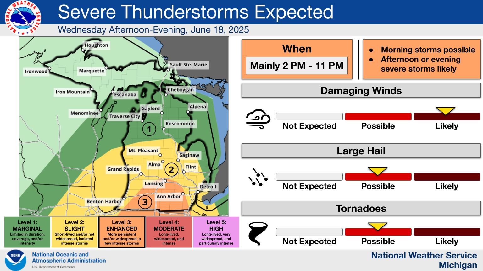
According to the NOAA Storm Prediction Center, most of the Lower Peninsula is under a “slight risk” (Level 2 of 5) for severe thunderstorms, while the remainder of the Lower Peninsula faces a “marginal risk” (Level 1) Southern counties have a 15–29% chance of severe weather
Rapid Radios are push to talk nationwide walkie talkies. They work when your cell phone company services goes down. Click here to learn more.
TIMING & THREATS
-
Timing: Storms are expected to develop during the afternoon and persist into the evening and overnight hours. The highest threat period is from noon through midnight, with mid-to-late afternoon being critical
-
Main threats: Damaging wind gusts will be the primary risk. Hail, flooding, and isolated tornadoes cannot be ruled out — especially if storms organize into supercell clusters
-
Local variations: West Michigan (including Grand Rapids) is included in the slight risk zone, with storm arrival expected between 6–8 p.m. Southeast Michigan, including Metro Detroit and surrounding counties, faces damaging wind, large hail, and flooding potential, with the threat level at slight to marginal
REGIONAL FORECASTS
-
Bay City & Flint areas can expect a 70–90% chance of showers and thunderstorms Wednesday, with highs in the upper 70s to mid‑80s. Rainfall amounts may reach 0.25 to 0.75 inches, with overnight totals possibly topping an inch .
-
Ann Arbor residents should prepare for likely showers and storms after 5 p.m., with similar rainfall amounts and gusty winds approaching 18–21 mph